The History of EMMET COUNTY, 1884Page 127-129 |
CHAPTER XVII
LOCATION-SOIL-TIMBER AND STREAMS-AGRlCULTURAL RESOURCES
CLIMATE-RAILWAY STATIONS and POST OFFICES
Emmet County is situated on the eastern shore of Lake Michigan, and immediately south of the Straits of Mackinaw, in latitude between 451 and 460 north. This county is noted for its great extent of coast; including Little Traverse Bay, it has nearly sixty miles, it is bounded on the north by the Straits of Mackinac, on the east by Cheboygan, on the south by Charlevoix and Little Traverse Bay, and on the west by Lake Michigan. It has an area of 414 square miles, and had a population in 1880 of 6,639.
There were 2,344 acres of government, 4,550 acres of state swamp, 2,773 acres of primary school, and 160 acres of Grand Rapids & Indiana Railroad lands, subject to entry May 1, 1883.
A state road extends from Charlevoix, in Charlevoix County, to Petoskey, thence northeast to, Cheboygan; one runs east from Petoskey to Presque Isle County, on Lake Huron; one also runs from Petoskey southeast to Gaylord, Otsego County; another runs from Boyne City, in Charlevoix County, to Clarion, to intersect the last named road, and still another runs from Harbor Springs in an easterly direction to intersect the first named road.
Lumbering is an important industry on the Maple and Cart Rivers, also along the Grand Rapids & Indiana Railroad. Ties, posts, tan-bark, and telegraph poles, are gotten out in large quantities. The fishing industry is by no means an inconsiderable one; a number of men and boats are employed in this business at Petoskey and Harbor Springs. The Grand Rapids & Indiana Railroad crosses the county on its way to Mackinac, and a branch extends
 Click on this little map and it will take you to a VERY large version of the same map (638k) | from Petoskey to Harbor Springs.
Little Traverse Bay, and the resorts along its banks, have become famous, owing to the wonderful climatic advantages.
The following map is furnished by the Petoskey Record and is designed to show the relative position of Emmet County and Little
Traverse Bay, including the resorts around the bay. SOIL, TIMBER AND STREAMS Emmet County is noted for its fertility of soil, and immense growth of hard wood timber. The general surface is characterized by ridges, extending north and south. There are four of these ridges or ranges of hills, commencing on the north side of Little Traverse Bay. Two or three miles from the east shore of the lake commences the first range, rising to an altitude of about 350 feet, then descending gradually to a valley varying from one mile to two miles in width. Then commences another range like the fir3t, ranning parallel, and also descending into a valley. So on to the fourth range, which reaches an altitude of some 600 feet above the water in the lake. The valleys are undulating, and vary in altitude from 100 to 300 feet. Many parts of these ridges are table lands, where the very best farming lands are to be found, with great fertility of soil, and susceptible of the highest state of cultivation, while the hills are equally fertile, but better adapted to fruit or for grazing purposes. The valleys include the meadow lands, which are much the same character of soil as the ridges, and are adapted to all the varied purposes of agriculture. |
The region immediately around Little Traverse Bay, and extending in a narrow belt across the southern part of Emmet County belongs to the old Devonian age, and is known in the geological charts of Michigan as the “Little Traverse group.” The northern part of the county belongs to the corniferous period.
The flora of Emmet County is very rich. Not only is the face of the country covered with a dense forest of magnificent hard wood trees, but a wonderfully luxuriant undergrowth of wild fruit, vines, and flowers, make our woods a paradise for the botanist.
The timber is principally maple, beech, linn or basswood, elm, and ash, maple being the most common of all. Pine and other varieties, grow in some localities, but not in sufficient quantities to make them an object of special mention. Great quantities of bird's-eye maple grow in this county, but it is confined to a great extent to the smaller class of timber, yet a sufficient quantity exists of the larger growth to make it an important article of manufacture, and it will be a source of wealth to the farmer. In some parts of the eastern and northern portions of the county are extensive cedar swamps or flats, furnishing an, inexhaustible supply of timber for fencing, coopermaking and other purposes. They are supplied with the purest spring water, and are sufficiently elevated to be easily drained. When cleared of their dense growth of timber, they can be easily converted into the finest grazing and meadowlands in the state.
| The county, though well supplied with fine springs of pure water, is not noted for its extensive streams. Maple River, the principal stream, heads on the north, and bears south through the eastern portion of the county, emptying into Crooked Lake, east of Little Traverse Bay. This stream is sufficiently large for rafting purposes, and is susceptible of slack water navigation; it also has sufficient fall for milling purposes. The improvement of Crooked River for navigation, in connection with Maple River, is aiding development of the entire eastern portion of the county. The next stream of any importance is Bear Creek, entering into Little Traverse Bay at Petoskey. This stream has a magnificent water power, which, however, is only partially developed. It has its source in Bear Lake, in Charlevoix County. These, with one other stream, entering the Straits on the north, | 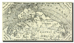
|
AGRICULTURAL RESOURCES
The agricultural resources of this county, when properly developed, will not be excelled by any in the state. All the staple products of agriculture grown in the north are produced here in abundance. Wheat, oats, rye, barley, buckwheat and corn all succeed above the average of districts considered more favored as to climate, with the exception of corn. The soil seems to be admirably adopted to the successful raising of root crops. Potatoes, turnips, ruta bagas, carrots, etc., all succeed beyond the expectation of the most sanguine. Some of these lands were cultivated by the French and Indians a centuryago, and these crops are produced on these old farms, and consequently such productiveness is not to be attributed to new and strong ground.
The following table, giving the average yield of the mission farm at Cross Village, is taken from the records kept by Father Weikamp for a long series of years, and is entirely reliable. It may be stated also that the land in the mission farm is not exceptionally good. There are thousands of acres of better land within the county. For twenty years the average yield per acre upon the mission farm has been of:
Wheat..............30 Bushels
Oats.................60 Bushels
Rye...................27 Bushels
Barley..............26 Bushels
Potatoes.........100 Bushels
Beets..............400 Bushels
Carrots..........400 Bushels
Turnips..........500 Bushels
Rutabagas......500 Bushels
Timothy Hay...21 Tons
CLMATE
The meteorological record, carefully kept for over a quarter of a century at the convent in Cross Village, justifies the statement, that while the heat is never so great in summer, the cold is never so severe, as in southern Michigan and northern Indiana and Ohio. During the winters of 1883 and 1881, both unusually severe, the mercury did not reach so low a point by 10 degrees as recorded for central Ohio and Indiana. The winter of '71-'72 was marked by extreme severity all over the west and south, as far as Nashville, Tennessee, the thermometer standing as low as 25 degrees and 30 degrees below zero, and even 32 degrees below in Kansas and St. Louis. At the same time it only reached 14 degrees below zero at Island of Mackinaw, according to the record of the Rev. Mr. Stonex, the Episcopal minister of that place. Take the winter of '74-'75, which was marked with extreme severity over the entire continent, carrying the thermometer down at different times to 25 degrees and 30 degrees below zero, at points four hundred miles to the south of us, and gradually intensifying northward until it reached 52 degrees below, at Sparta, Wisconsin, one hundred and fifty miles south of us; 46 degrees below at Grand Rapids; 36 degrees below at Traverse City; 31 degrees below at Petoskey; and 23 degrees below at Little Traverse; showing that on the west side of the lake this cold intensified as it went north, but on the east side of the lake it moderated, proving conclusively that here the influence of the waters unite.
This county lies near the junction of the three great lakes. East and west the water is more than double the extent of the land. A southwest wind brings a water influence of over one hundred and eighty miles; a direct west wind, including Green Bay, of one hundred and ten miles; while a northwest wind sweeps over Lake Superior, then seventy miles over Lake Michigan. A northeast, east, and southeast wind is from off Lake Huron. Here the influence of the waters finite, and will forever prevent extreme changes.
RAILWAY LINES AND STATIONS
The Grand Rapids & Indiana Railroad was built to Petoskey and commenced business in the spring of 1874. In 1876 it was extended to Bay View and in l882 to Mackinaw City. The line from Bay View to Mackinaw City is known as the Grand Rapids to Mackinaw line. The branch to Harbor Springs was finished 1880. The following named railway stations are in Emmet County: Clarion, Petoskey, Bay View, Harbor Springs Junction, Conway, Oden, Alanson, Brutus, Pellston, Levering, Carp Lake. On the line to Harbor Springs, Wequetonsing, and Bay View.
POST OFFICES
The following, are names of post offices in Emmet County: Alanson, Ayr, Bliss, Brutus, Carpenter, Carp Lake, Conway, Cross Village, Ely, Epsilon, Good Hart, Harbor Springs, Littlefield, Lonsdale, Oden, Pellston, Petoskey, Pleasant View.
Continue to the next page...
[top of page]